Bundle Adjustment Of Hayabusa2’s ONC Images And Controlled Color Mosaic Map Of Ryugu
JAXA’s Hayabusa2 mission successfully returned samples from the asteroid Ryugu in December 2020. It executed two touchdowns to collect the surface and subsurface materials, one close to the crater created by an artificial impactor.
The onboard camera system, Optical Navigation Camera (ONC), with two wide-angle cameras and one narrow-angle camera with seven color filters, was crucial for mapping geomorphology and composition such as hydrated minerals during navigation and scientific observation.
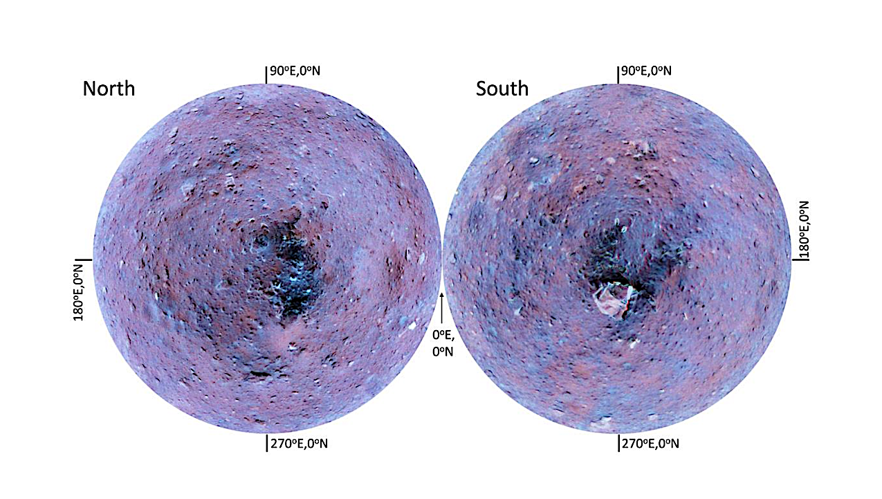
More than 8,300 images revealed Ryugu’s spinning-top shape and boulder-covered surface. However, most high-resolution images captured during descent/touchdown operations lacked precise location data and camera position/orientation information. Image geometry was refined using photogrammetric bundle adjustment.
This method enabled the refinement of all high-resolution images captured during descent/touchdown operations. Furthermore, map-projected GeoTIFF images in GIS format containing geographic metadata were created for all ONC images, and these were integrated to construct global and regional mosaic maps.
To facilitate scientific research on Ryugu, these refined image geometry information, maps, and mosaics are publicly available via https://dataverse.harvard.edu/dataset.xhtml?persistentId=doi:10.7910/DVN/WW3IH0
Naoyuki Hirata, Eri Tatsumi, Mayumi Ichikawa, Kazuhiro Honda, Sayuri Tanaka
Comments: 20 pages, 5 figures
Subjects: Earth and Planetary Astrophysics (astro-ph.EP); Instrumentation and Methods for Astrophysics (astro-ph.IM)
Cite as: arXiv:2602.12554 [astro-ph.EP] (or arXiv:2602.12554v1 [astro-ph.EP] for this version)
https://doi.org/10.48550/arXiv.2602.12554
Focus to learn more
Related DOI:
https://doi.org/10.7910/DVN/WW3IH0
Focus to learn more
Submission history
From: Naoyuki Hirata
[v1] Fri, 13 Feb 2026 03:03:11 UTC (977 KB)
https://arxiv.org/abs/2602.12554
Astrobiology,