New Models Suggest Little Groundwater Recharge In Ancient Mars Aquifer
Mars was once a wet world. The geological record of the Red Planet shows evidence for water flowing on the surface – from river deltas to valleys carved by massive flash floods.
But a new study shows that no matter how much rainfall fell on the surface of ancient Mars, very little of it seeped into an aquifer in the planet’s southern highlands.
A graduate student at The University of Texas at Austin made the discovery by modeling groundwater recharge dynamics for the aquifer using a range of methods – from computer models to simple back-of-the-envelope calculations.
No matter the degree of complexity, the results converged on the same answer – a miniscule .03 millimeters of groundwater recharge per year on average. That means that wherever rain fell in the model, only an average of .03 millimeters per year could have entered the aquifer and still produced the landforms remaining on the planet today.
For comparison, the annual rate of groundwater recharge for the Trinity and Edwards-Trinity Plateau aquifers that provide water to San Antonio generally ranges from 2.5 to 50 millimeters per year, or about 80 to 1,600 times the Martian aquifer recharge rate calculated by the researchers.
There are a variety of potential reasons for such low groundwater flow rates, said lead author Eric Hiatt, a doctoral student at the Jackson School of Geosciences. When it rained, the water may have mostly washed across the Martian landscape as runoff. Or it may have just not rained very much at all.
These findings can help scientists constrain the climatic conditions capable of producing rainfall on early Mars. They also suggest a very different water regime on the Red Planet than what exists on Earth today.
“The fact that the groundwater isn’t as big of a process could mean that other things are,” Hiatt said. “It might magnify the importance of runoff, or it could mean that it just didn’t rain as much on Mars. But it’s just fundamentally different from how we think about [water] on Earth.”
The results were published in the journal Icarus. The paper’s co-authors are Mohammad Afzal Shadab, a doctoral student at the Jackson School and faculty members Sean Gulick, Timothy Goudge and Marc Hesse.
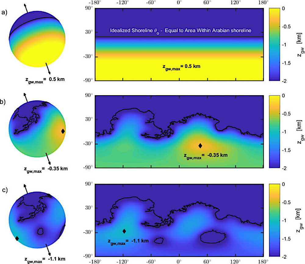
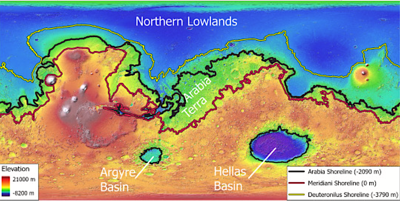
Effect of complex geometry for an aquifer with a recharge flux of 10−2 mm/yr evenly distributed between −45 and 45 : (a) Analytic solution from Eq. (4) with mean Arabia shoreline. (b) Numerical solution with Arabia shoreline. (c) Numerical solution with Arabia shoreline and standing water in Hellas and Argyre basins. The hydraulic head level in the basins is assumed to be equal to the Arabia shoreline elevation. All numerical solutions presented in this work assume a hydraulic conductivity of and assume that all basins have shoreline elevations equivalent to the Arabia Terra shoreline at m. Results for other shorelines are provided in the SI Section S4.3 and S4.4. — Icarus.
The models used in the study work by simulating groundwater flow in a “steady state” environment where inflow and outflow of water into the aquifer is balanced. Scientists then changed the parameters affecting the flow – for example, where rain falls or the average porosity of the rock – and observed what other variables would have to change to maintain the steady state and how plausible those charges are.
While other researchers have simulated groundwater flow on Mars using similar techniques, this model is the first to incorporate the influence of the oceans that existed on the surface of Mars more than three billion years ago in the Hellas, Argyre, and Borealis basins.
The study also incorporates modern topographical data collected by satellites. The modern landscape, Hiatt said, still preserves one of the planet’s oldest and most influential topographical features – an extreme difference in elevation between the northern hemisphere – the lowlands – and the southern hemisphere – the highlands – known as the “great dichotomy.” The dichotomy preserves signs of past groundwater upwelling in which groundwater rose up from the aquifer to the surface. The researchers used geological markers of these past upwelling events to evaluate different model outputs.
Across different models, the researchers found the mean groundwater recharge rate of .03 millimeters per year to match most closely with what’s known about the geologic record.
The research isn’t just about understanding the Red Planet’s past. It has implications for future Mars exploration too. Understanding groundwater flow can help inform where to find water today, Hiatt said. Whether you’re looking for signs of ancient life, trying to sustain human explorers, or making rocket fuel to get back home to Earth, it’s essential to know where the water would most likely be.
The research was funded by NASA, the University of Texas Institute for Geophysics, and the UT Center for Planetary Habitability.
‘
Limited recharge of the southern highlands aquifer on early Mars, Icarus (open access)
Astrobiology