Ice World Exploration: New Map Unlocks Deep Digital Data Of Antarctica’s History
Today marks a ground-breaking transformation in global Antarctic research, and a new way we understand the frozen continent.
Documentation of the first open-access and comprehensive geological database of Antarctica, GeoMAP Antarctica was released today in Nature Scientific Data on the 19th May 2023 (PST).
GeoMAP is a world-first geological mapping database of Antarctica
GeoMAP is the first detailed geological mapping database of the entire continent that collates all the historical and existing geological data of Antarctica.
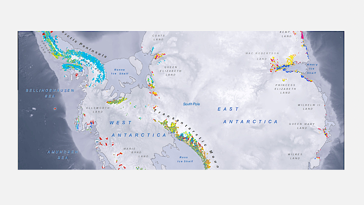
Despite Antarctica’s reputation as an icy expanse, over 52,000 km2 of exposed rock and sediment make up the mountains and surfaces of the continent between the glaciers. Each of these areas contain important information on the continent’s geological, geomorphological, and glaciological history. GeoMAP is the first open-access mapping database that provides a detailed geological account of what we know about the continent, all in one place.
Despite Antarctica’s reputation as an icy expanse, over 52,000 km2 of exposed rock and sediment make up the mountains and surfaces of the continent between the glaciers. Each of these areas contain important information on the continent’s geological, geomorphological, and glaciological history. GeoMAP is the first open-access mapping database that provides a detailed geological account of what we know about the continent, all in one place.
GeoMAP provides foundational knowledge for cross-discipline research
Geological knowledge of the continent’s mountains, sediments and soils, helps pinpoint the location, history and movement of glaciers, and even meltwater production. These insights provide foundational knowledge for researchers, from climate scientists, to biologists, to ecologists and volcanologists.
Scientists across disciplines have needed a more comprehensive digital dataset of Antarctica’s geology to examine how rock substrate influences biology and ecology, local climate and melting, and the behaviour of ice. In turn this is important for understanding the continent’s role in global climate and sea level rise and effects of climate change on the continent itself.
Project leader Simon Cox from GNS Science says “GeoMAP has achieved exactly this by capturing and refining all the existing geological map data of Antarctica. We have purposefully created GeoMAP to be a fundamental, continent-wide, and open-access digital resource. We believe GeoMAP will be used in, and evolve with, a wide breadth of future research across the world.”
Simon continues, “It may not be a first port of call for specialists undertaking detailed research, but all the information is present to provide introductory and essential overviews.”
For geologists, GeoMAP brings together geological unit information to provide an unprecedented level of detail about the continent’s geology. The data includes detail about unit type, name, age, lithology, stratigraphy, previous work and supporting background information, making it a valuable resource for researchers and scientists.
Constructing GeoMAP was a large international effort led out of the Scientific Committee on Antarctic Research (SCAR) by GNS Science in New Zealand. The work involved principal collaborators from USA, Norway, Italy, UK, Australia, Russia and New Zealand, and contributions from at least 14 nations.
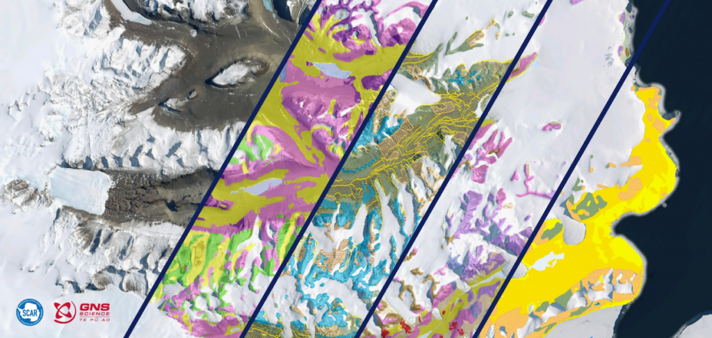
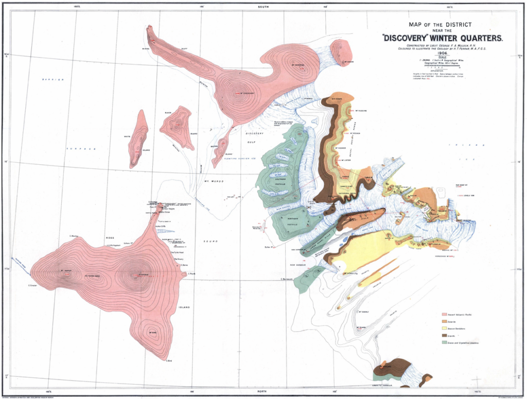
GeoMAP successfully weaves original observations from heroic age Antarctica expeditions with today’s modern datasets. To achieve this world-first, the scientists mined and collated all existing geological data across a range of sources, but also maintained links to all those original studies. This effort took several years and included interpreting information from beautiful 20th Century hand-drawn maps, digitising hard-copy regional maps, and integrating them with modern high-resolution imagery and datasets.
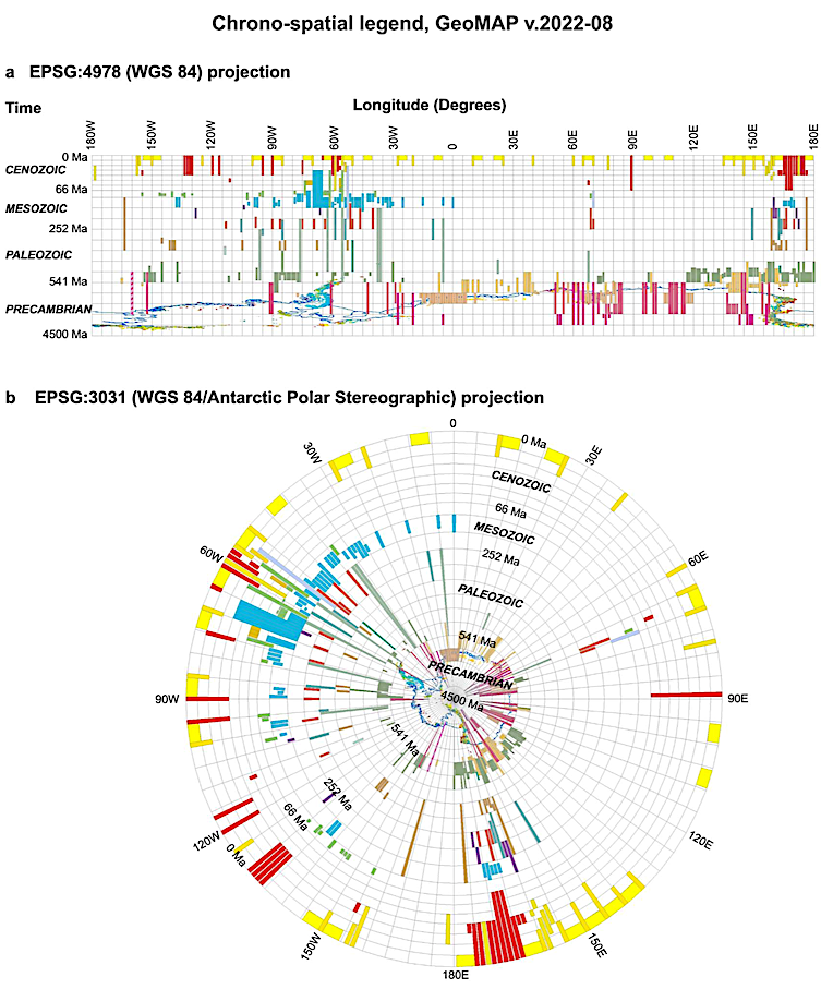
Lead data architect, Belinda Smith Lyttle from GNS Science says, “One of the hardest tasks in creating GeoMAP was building consistency and capturing the local nuances of different interpretations available. Nevertheless, with over 99,000 geological polygons classified into 186 chronostratigraphic units and 21 simplified geological classes, the GeoMAP team is confident that this has been achieved.”
Belinda continues, “Nonetheless, there are many areas yet to be visited by any geologist, and other areas where very detailed mapping has yet to be captured – and there is always new research taking place – so the GeoMAP database has been designed to be editable and improved over time.”
Now, the entire GeoMAP dataset can be accessed online
GeoMAP can be downloaded for free, and illustrated with high-resolution 3D fly-through videos.
The world-leading collaboration and achievement of GeoMAP has set a new standard for Antarctic geological knowledge and represents a major contribution to understanding the frozen continent.
For geological knowledge, GeoMAP now compliments Antarctica’s reputation as the “continent of science and collaboration”.
VIEW GEOMAP ANTARCTICA DATA HERE
For media enquires, email [email protected]
Astrobiology