Perseverance Rover Retrieves Key Rocky Clues To Mars’ Geologic And Water History
In its first year exploring Jezero Crater on Mars, the Perseverance rover collected rock samples that scientists anticipate will provide a long-awaited timeline for the planet’s geologic and water history.
They’ll just have to wait a decade to find out the answer, until the samples can be scooped up from the surface and returned to Earth for dating in 2033.
The scientists are nevertheless enthused by what they’ve discovered so far about the samples. These discoveries are outlined in a paper that will appear Aug. 25 in the journal Science, with more detailed analyses in a second Science paper and two other papers published online simultaneously in Science Advances.
Jezero Crater, just north of the Martian equator, was a target for NASA’s Mars 2020 Mission and its Perseverance rover because it contained what looked like a river delta that formed inside a lake bed and thus could potentially tell scientists about when water flowed on the planet’s surface. Rocks collected from the floor of the crater underlie the delta sediments, so their crystallization ages will provide an upper limit for the delta’s formation, according to geochemist David Shuster, professor of earth and planetary science at the University of California, Berkeley.
“When that delta was deposited is one of the main objectives of our sample return program, because that will quantify when the lake was present and when the environmental conditions were present that could possibly have been amenable to life,” said Shuster, who is a member of NASA’s science team for sample collection, one of three main authors of the Science paper that summarizes the work and co-author of two of the three other papers.
The two other lead authors of the summary Science paper are geochemist Kenneth Farley of Caltech, Perseverance’s project scientist, and Mars 2020 Deputy Project Scientist Katherine Stack Morgan of NASA’s Jet Propulsion Laboratory (JPL).
The main surprise, Shuster said, is that the rocks collected from four sites on the floor of Jezero Crater are igneous cumulate rocks — that is, they were formed by the cooling of molten magma and are the best rocks for precise geochronology once the samples have returned to Earth. They also show evidence of having been altered by water.
“From a sampling perspective, this is huge,” he said. “The fact that we have evidence of aqueous alteration of igneous rocks — those are the ingredients that people are very excited about, with regard to understanding environmental conditions that could potentially have supported life at some point after these rocks were formed.”
“One great value of the igneous rocks we collected is that they will tell us about when the lake was present in Jezero. We know it was there more recently than the igneous crater floor rocks formed,” Farley said. “This will address some major questions: When was Mars’ climate conducive to lakes and rivers on the planet’s surface? And when did it change to the very cold and dry conditions we see today?”
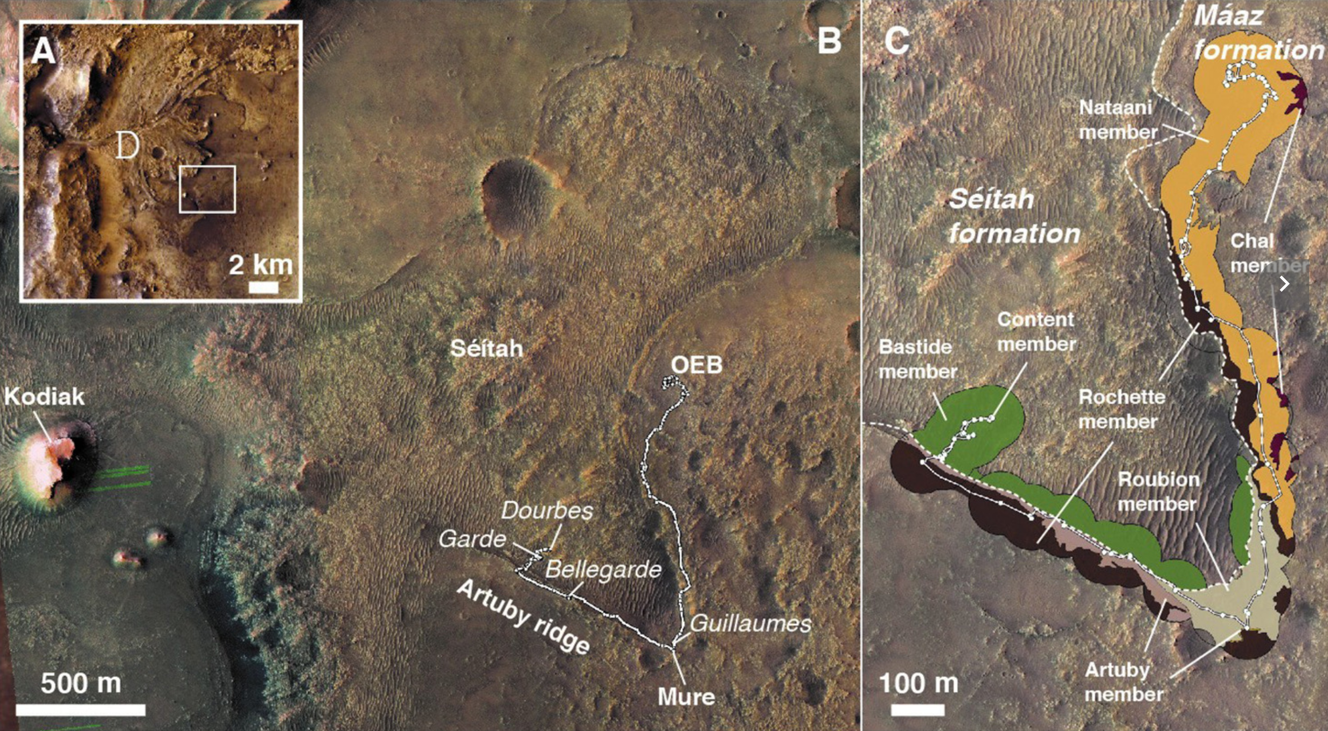
Before the mission, geologists expected that the floor of the crater was filled with either sediment or lava, which is molten rock that spilled onto the surface and cooled rapidly. But at two sites referred to as Séítah — the Navajo word for “amidst the sand” — the rocks appear to have formed underground and cooled slowly. Evidently, whatever was covering them has eroded away over the past 2.5 to 3.5 billion years.
“We literally debated for the first nine months, as we were driving around on the crater floor, whether the rocks that we’re looking at are sediments that were deposited into a lake, or igneous rocks,” he said. “In fact, they are igneous rocks. And the form of the igneous rocks that we found is quite surprising, because it doesn’t look like a simple volcanic rock that flowed into the crater. Instead, it looks like something that formed at depth and cooled gradually in a largish magma chamber.“
The crystal structure of the igneous rock — not unlike the granite of the Sierra Nevada, but with different composition and much more finely grained — showed millimeter-sized grains of olivine intergrown with pyroxene that could only have been formed by slow cooling. The coarse-grained olivine is similar to that seen in some meteorites that are thought to have originated on Mars and eventually crashed into Earth. The data supporting this came from multispectral images and X-ray fluorescence analysis by instruments aboard Perseverance and are detailed in a second Science paper by lead author Yang Liu, a planetary geologist at JPL.
Séítah and Máaz sites
According to Shuster, the data allow for a couple of scenarios that explain the igneous rocks on the crater floor.
“Either the rock cooled underground and came up from below, somehow, or there was something like a magma lake that filled up the crater and cooled gradually,” he said.
Samples from a second nearby site called Máaz — Mars in the Navajo language — are igneous also, but of a different composition. Because this layer overlies the layer of igneous rock exposed at Séítah, the Máaz rock could have been the upper layer of the magma lake. In magma lakes on Earth, the denser minerals settle downward as they crystalize, creating layers of different compositions. These types of igneous formations are called cumulate, which means they formed by the settling of iron- and magnesium-enriched olivine and the subsequent multi-stage cooling of a thick magma body.
The Máaz igneous rocks could also be from a later volcanic eruption.
In either case, the upper layer that has partly eroded away could have been on the order of hundreds of meters thick, Shuster said.
Both the slow-cooled rocks at Séítah and the potentially more rapidly-cooled rocks at Máaz showed alteration by water, though in different ways. The Máaz rocks contained pockets of minerals that may have condensed from salty brine, while the Séítah rocks had reacted with carbonated water, according to chemical analyses onboard the rover.
The precise times when these various layers formed will be revealed only by lab analysis on Earth, since the geochemical analysis tools required for dating are too large to have been placed aboard Perseverance.
“There are a variety of different geochemical observations that we can make in these rocks when we return them to Earth. That will give us all sorts of information about that igneous environment,” he said. “We can figure out when the rock crystallized, which is one of the things that I’m most excited about for providing a delta timing constraint. But it also gives us information about when igneous activity was occurring in the planet’s interior. Combined with satellite imagery, we can then relate that to some of the bigger-picture, more regional igneous activity.”
Shuster noted that duplicate rock samples were taken at each of the four sites and that, within a year, will be cached along with other duplicate samples at a contingency site near the delta, to be used only if the primary samples onboard Perseverance become inaccessible because of mechanical failure. That future cache will also include recently collected samples of sediments from the delta itself — details of which are being prepared for a future scientific paper.
Aqueously altered igneous rocks sampled on the floor of Jezero crater, Mars, Science (Open Access)
Astrobiology,