Orbital Recon: How Life On Earth Can Be Measured From Space
Measurements and data collected from space can be used to better understand life on Earth.
An ambitious, multinational research project funded by NASA and co-led by UC Merced civil and environmental engineering Professor Erin Hestir demonstrated that Earth’s biodiversity can be monitored and measured from space, leading to a better understanding of terrestrial and aquatic ecosystems. Hestir led the team alongside University of Buffalo geography Professor Adam Wilson and Professor Jasper Slingsby from the University of Cape Town on BioSCape, which collected data over six weeks in late 2024.
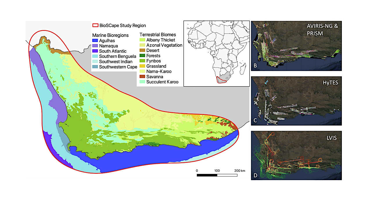
Two NASA aircraft and one South African aircraft flew over South Africa’s Greater Cape Floristic Region —one of the most biodiverse places on the planet — to collect ultraviolet, visual, thermal and other images. That data, combined with field work by the large team of scientists from the United States and South Africa, provides a comprehensive look at the region’s biodiversity, or life systems.
“This was NASA’s first ever biodiversity-focused campaign,” Hestir said. “We successfully hit all our measurement targets, and the data collected are contributing to novel techniques and methods to be able to monitor biodiversity from space across the globe. It’s a lot of exciting science.”
Wilson said BioSCape showed what scientists working across continents can do, and he hopes it can be replicated elsewhere.
“Over just six weeks, more than 160 scientists from around the world came together to collect and analyze data across terrestrial, marine and freshwater ecosystems in one of the world’s biodiversity hotspots.”
The team recently published two papers on BioSCape, in the publications Nature Reviews Biodiversity and npj Biodiversity.
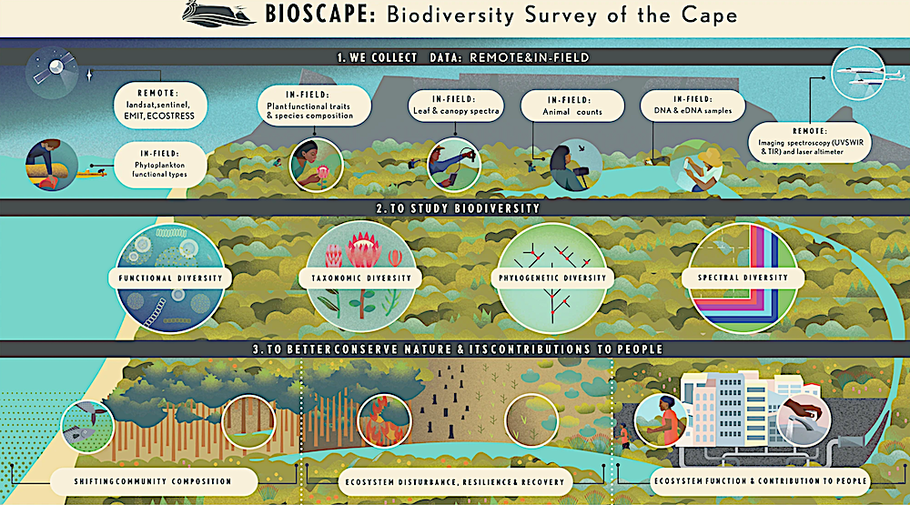
Airborne data were acquired contemporaneously with a variety of field measurements of biodiversity. These data are processed through models and algorithms to produce products that inform our understanding of functional, taxonomic, phylogenetic, and spectral dimensions of biodiversity. Applying these biodiversity data products will help inform the measuring and management of biodiversity resources and nature’s contribution to people (Artwork created by J.Silver under contract with BioSCape).
Once researchers proved they could collect the data they were looking for from planes, NASA could use the novel combinations of instruments to expand the effort worldwide.
“It’s very expensive to launch a satellite into space,” Slingsby explained. “You have to be certain it will achieve its mission before taking that step. That’s why we begin with airborne studies — they serve as a critical proving ground. If we can successfully gather data from a plane, it brings us one step closer to understanding how to achieve the same from space.”
The team chose the Greater Cape Region of South Africa because it’s home to “astonishing levels of biodiversity, wicked conservation challenges and a well-developed and progressive biodiversity research and conservation community,” they wrote.
The tools they developed helped them examine shifting community composition; ecosystem disturbance, resilience and recovery; and ecosystem function and nature’s contributions to people.
Addressing biodiversity loss is a global priority and there is a clear need to improve scientists’ ability to map and monitor change. The researchers made the data freely available to scientists and the public around the world. Their hope is that the methods they developed and insights they found will help shape new technologies for measuring land and sea ecosystems and ultimately improve biodiversity conservation.
They are excited to see what comes next.
“BioSCape is building technical capacity in South Africa and we hope to prepare the community to take advantage of NASA’s advanced and freely available satellite imagery to improve conservation,” said Anabelle Cardoso, the science team manager.
“In a year from now we will have new findings and better insights,” Hestir said, “advancing cutting-edge technology so we can measure life on Earth from space.”
The biodiversity survey of the Cape(BioSCape), integrating remote sensing with biodiversity, Science (open access)
Astrobiology,