What Turned Earth Into A Giant Snowball 700 Million Years Ago?
Australian geologists have used plate tectonic modelling to determine what most likely caused an extreme ice-age climate in Earth’s history, more than 700 million years ago.
The study, published in Geology, helps our understanding of the functioning of the Earth’s built-in thermostat that prevents the Earth from getting stuck in overheating mode. It also shows how sensitive global climate is to atmospheric carbon concentration.
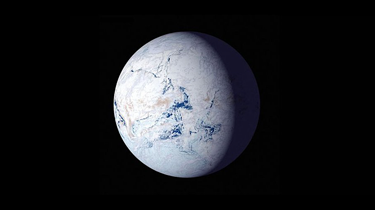
“Imagine the Earth almost completely frozen over,” said the study’s lead author, ARC Future Fellow Dr Adriana Dutkiewicz. “That’s just what happened about 700 million years ago; the planet was blanketed in ice from poles to equator and temperatures plunged. However, just what caused this has been an open question.
“We now think we have cracked the mystery: historically low volcanic carbon dioxide emissions, aided by weathering of a large pile of volcanic rocks in what is now Canada; a process that absorbs atmospheric carbon dioxide.”
The project was inspired by the glacial debris left by the ancient glaciation from this period that can be spectacularly observed in the Flinders Ranges in South Australia.
A recent geological field trip to the Ranges, led by co-author Professor Alan Collins from the University of Adelaide, prompted the team to use the University of Sydney EarthByte computer models to investigate the cause and the exceptionally long duration of this ice age.
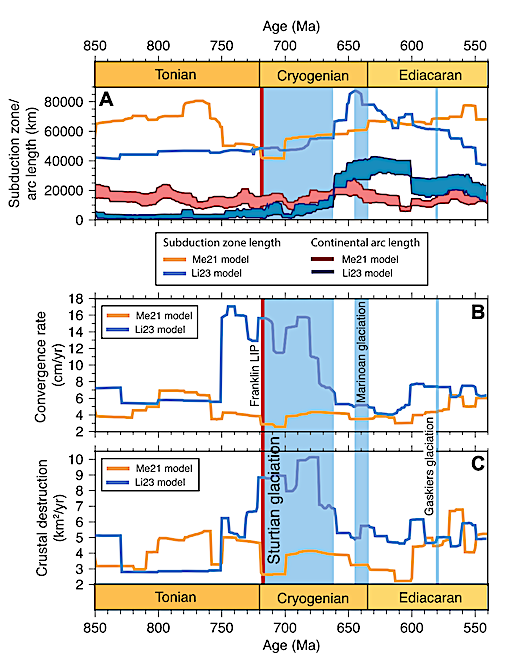
Global subduction parameters for the plate motion models Me21 (Merdith et al., 2021) and Li23 (Li et al., 2023b). (A) Subduction zone length and continental arc length. Minimum and maximum continental arc lengths are based on arc-trench distances of 250 km and 450 km, respectively, following Pall et al. (2018). (B) Plate convergence rate. LIP—large igneous province. (C) Crustal destruction rate. Labeling as in Figure 2.
The extended ice age, also called the Sturtian glaciation after the 19th century European colonial explorer of central Australia, Charles Sturt, stretched from 717 to 660 million years ago, a period well before the dinosaurs and complex plant life on land existed.
Dr Dutkiewicz said: “Various causes have been proposed for the trigger and the end of this extreme ice age, but the most mysterious aspect is why it lasted for 57 million years – a time span hard for us humans to imagine.”
The team went back to a plate tectonic model that shows the evolution of continents and ocean basins at a time after the breakup of the ancient supercontinent Rodina. They connected it to a computer model that calculates CO2 degassing of underwater volcanoes along mid-ocean ridges – the sites where plates diverge and new ocean crust is born.
They soon realised that the start of the Sturtian ice age precisely correlates with an all-time low in volcanic CO2 emissions. In addition, the CO2 outflux remained relatively low for the entire duration of the ice age.
Dr Dutkiewicz said: “At this time, there were no multicellular animals or land plants on Earth. The greenhouse gas concentration of the atmosphere was almost entirely dictated by CO2 outgassing from volcanoes and by silicate rock weathering processes, which consume CO2.”
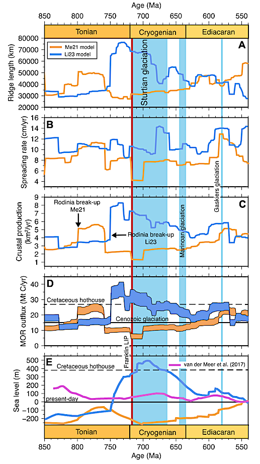
Tectonic parameters for plate motion models Me21 (Merdith et al., 2021) and Li23 (Li et al., 2023b). Blue bars indicate glacial intervals with ages from Walzer and Hendel (2023). Red bar is the Franklin large igneous province (LIP) with emplacement age from Dufour et al. (2023). (A) Ridge length. (B) Spreading rate. (C) Crustal production rate (ridge length × spreading rate). (D) Mid-ocean ridge (MOR) (outflux of CO2 expressed as weight/yr of carbon). The error envelope primarily reflects the uncertainty in upper mantle CO2 content (Müller et al., 2022). Mean MOR outflux for the onset of the last glaciation at ca. 34 Ma (black line) and for the Cretaceous hothouse climate at 120 Ma (black dashed line) are from Müller et al. (2022). (E) Eustatic sea level computed as a function of the difference in mean oceanbasin depth relative to the present-day (black line), including the effect of isostasy (see text). Black dashed line indicates sea level at 120 Ma based on the same method (see Fig. S1 in the Supplemental Material [see text footnote 1]). The van der Meer et al. (2017) curve is derived from seawater 87Sr/86Sr ratios.
Co-author Professor Dietmar Müller from the University of Sydney said: “Geology ruled climate at this time. We think the Sturtian ice age kicked in due to a double whammy: a plate tectonic reorganisation brought volcanic degassing to a minimum, while simultaneously a continental volcanic province in Canada started eroding away, consuming atmospheric CO2.
“The result was that atmospheric CO2 fell to a level where glaciation kicks in – which we estimate to be below 200 parts per million, less than half today’s level.”
The team’s work raises intriguing questions about Earth’s long-term future. A recent theory proposed that over the next 250 million years, Earth would evolve towards Pangea Ultima, a supercontinent so hot that mammals might become extinct.
However, the Earth is also currently on a trajectory of lower volcanic CO2 emissions, as continental collisions increase and the plates slow down. So, perhaps Pangea Ultima will turn into a snowball again.
Dr Dutkiewicz said: “Whatever the future holds, it is important to note that geological climate change, of the type studied here, happens extremely slowly. According to NASA, human-induced climate change is happening at a pace 10 times faster than we have seen before.”
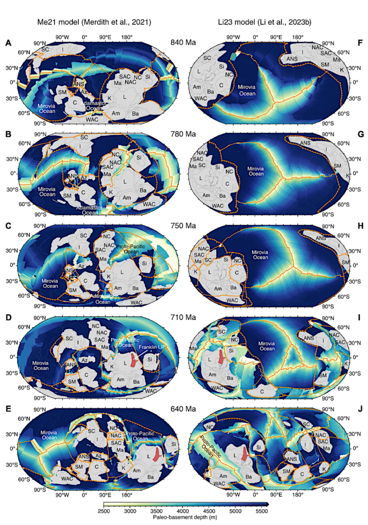
Rodinia reconstructions using the plate motion models Me21 (Merdith et al., 2021) (A–E) and Li23 (Li et al., 2023b) (F–J) overlying basement depth (see text). Orange lines are mid-ocean ridges, orange lines with teeth are subduction zones, and the red polygon is the Franklin large igneous province (LIP; Ernst et al., 2021). Cratonic crust (dark gray outlines) is annotated as: Am—Amazonia; ANS— Arabian-Nubian Shield; Az—Azania; Ba—Baltica; C—Congo; I—India; K— Kalahari; L—Laurentia; Ma—Mawson; NAC— North Australian Craton; NC—North China; SAC— South Australian Craton; SC—South China; Si— Siberia; SM—Sahara Metacraton; WAC—West African Craton. Light gray areas outside of the dark gray outlines are approximate extents of continental crust
RESEARCH
‘Duration of Sturtian “Snowball Earth” glaciation linked to exceptionally low mid-ocean ridge outgassing’, Dutkiewicz, A. et al (Geology, 2024). DOI: 10.1130/G51669.1 (open access)
Astrobiology, Astrogeology,