2001 Mars Odyssey Views A Volcano Poking Above Martian Clouds

Editor’s note: the NASA FY 2026 budget submitted by the White House would halt funding for 2001 Mars Odyssey despite its ability to do science for a tiny cost.
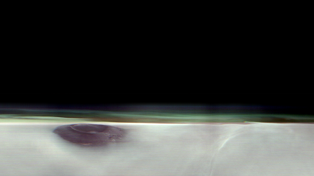
The 2001 Odyssey spacecraft captured a first-of-its-kind look at Arsia Mons, which dwarfs Earth’s tallest volcanoes.
A new panorama from NASA’s 2001 Mars Odyssey orbiter shows one of the Red Planet’s biggest volcanoes, Arsia Mons, poking through a canopy of clouds just before dawn. Arsia Mons and two other volcanoes form what is known as the Tharsis Montes, or Tharsis Mountains, which are often surrounded by water ice clouds (as opposed to Mars’ equally common carbon dioxide clouds), especially in the early morning. This panorama marks the first time one of the volcanoes has been imaged on the planet’s horizon, offering the same perspective of Mars that astronauts have of the Earth when they peer down from the International Space Station.
Launched in 2001, Odyssey is the longest-running mission orbiting another planet, and this new panorama represents the kind of science the orbiter began pursuing in 2023, when it captured the first of its now four high-altitude images of the Martian horizon. To get them, the spacecraft rotates 90 degrees while in orbit so that its camera, built to study the Martian surface, can snap the image.
The angle allows scientists to see dust and water ice cloud layers, while the series of images enables them to observe changes over the course of seasons.
“We’re seeing some really significant seasonal differences in these horizon images,” said planetary scientist Michael D. Smith of NASA’s Goddard Space Flight Center in Greenbelt, Maryland. “It’s giving us new clues to how Mars’ atmosphere evolves over time.”
Understanding Mars’ clouds is particularly important for understanding the planet’s weather and how phenomena like dust storms occur. That information, in turn, can benefit future missions, including entry, descent and landing operations.
Volcanic Giants
While these images focus on the upper atmosphere, the Odyssey team has tried to include interesting surface features in them, as well. In Odyssey’s latest horizon image, captured on May 2, Arsia Mons stands 12 miles (20 kilometers) high, roughly twice as tall as Earth’s largest volcano, Mauna Loa, which rises 6 miles (9 kilometers) above the seafloor.
The southernmost of the Tharsis volcanoes, Arsia Mons is the cloudiest of the three. The clouds form when air expands as it blows up the sides of the mountain and then rapidly cools. They are especially thick when Mars is farthest from the Sun, a period called aphelion. The band of clouds that forms across the planet’s equator at this time of year is called the aphelion cloud belt, and it’s on proud display in Odyssey’s new panorama.
“We picked Arsia Mons hoping we would see the summit poke above the early morning clouds. And it didn’t disappoint,” said Jonathon Hill of Arizona State University in Tempe, operations lead for Odyssey’s camera, called the Thermal Emission Imaging System, or THEMIS.
The THEMIS camera can view Mars in both visible and infrared light. The latter allows scientists to identify areas of the subsurface that contain water ice, which could be used by the first astronauts to land on Mars. The camera can also image Mars’ tiny moons, Phobos and Deimos, allowing scientists to analyze their surface composition.
More About Odyssey
NASA’s Jet Propulsion Laboratory, a division of Caltech in Pasadena, California, manages the Mars Odyssey Project for the agency’s Science Mission Directorate in Washington as part of NASA’s Mars Exploration Program portfolio. Lockheed Martin Space in Denver built the spacecraft and collaborates with JPL on mission operations. THEMIS was built and is operated by Arizona State University in Tempe.
For more about Odyssey: https://science.nasa.gov/mission/odyssey/
Astrobiology


