All-Sky Ultra-Narrowband Spectral Imaging with the OVRO-LWA: Technosignature Constraints and Axion-Like Particle Prospects
We present an imaging-domain search for technosignatures at decametric wavelengths with the OVRO-LWA, targeting ultra-narrowband continuous-wave signals between 50 and 86 MHz.
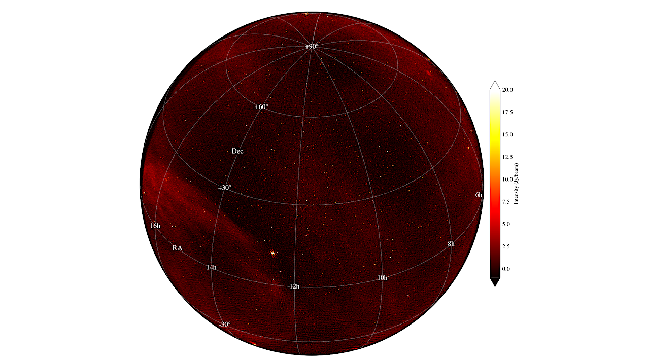
We implement an offline GPU pipeline that processes raw voltage data with upchannelization to approximately 10 Hz frequency resolution, producing all-sky images for each fine channel and totaling more than 3 x 10^6 images for a single 30 s epoch. Candidate selection is performed using multi-kernel matched filtering across frequency, empirical noise standardization, and false-discovery-rate control.
After applying quality cuts that remove extended sources, corrupted images, and obvious RFI, three narrowband candidates with signal-to-noise ratios above 10 sigma were selected for detailed analysis. By re-imaging these candidates with finer temporal and spectral resolution, we resolved their structure and found them to be inconsistent with compact celestial narrowband emitters.
Consequently, we report no detection of extraterrestrial technosignatures. The representative sensitivity of the search is ~100 Jy per channel across the entire visible hemisphere. For an unresolved emitter, this corresponds to 10 sigma equivalent isotropic radiated power (EIRP) limits of about 10^14 W at a distance of 10 pc and 10^18 W at 1 kpc.
The wide field of view and ultra-fine spectral resolution of this approach enable simultaneous probing of technosignature signals from millions of stellar systems. This method further establishes a scalable framework for deeper integrations and stacked searches toward neutron-star targets relevant to axion-like particle (ALP) line conversion.
Nikita Kosogorov, Gregg Hallinan, Greg Hellbourg, Marin M. Anderson, Judd D. Bowman, Ruby Byrne, Morgan Catha, Bin Chen, Xingyao Chen, Sherry Chhabra, Larry D’Addario, Ivey Davis, Jayce Dowell, Katherine Elder, Dale Gary, Charlie Harnach, Jack Hickish, Rick Hobbs, David Hodge, Mark Hodges, Yuping Huang, Andrea Isella, Daniel C. Jacobs, Ghislain Kemby, John T. Klinefelter, Matthew Kolopanis, James Lamb, Casey Law, Nivedita Mahesh, Surajit Mondal, Brian O’Donnell, Kathryn Plant, Corey Posner, Travis Powell, Vinand Prayag, Andres Rizo, Andrew Romero-Wolf, Jun Shi, Greg Taylor, Jordan Trim, Mike Virgin, Akshatha Vydula, Sandy Weinreb, Scott White, David Woody, Sijie Yu, Thomas Zentmeyer, Peijin Zhang, T. Joseph W. Lazio
Comments: 18 pages, 9 figures; accepted for publication in The Astronomical Journal
Subjects: Instrumentation and Methods for Astrophysics (astro-ph.IM)
Cite as: arXiv:2606.04304 [astro-ph.IM] (or arXiv:2606.04304v1 [astro-ph.IM] for this version)
https://doi.org/10.48550/arXiv.2606.04304
Focus to learn more
Submission history
From: Nikita Kosogorov
[v1] Wed, 3 Jun 2026 00:17:04 UTC (13,366 KB)
https://arxiv.org/abs/2606.04304
Astrobiology,