Ice Planet Update: Mysterious Patterns Revealed Under An Antarctic Ice Shelf
An international research team deployed the uncrewed submersible ‘Ran’ underneath 350 m thick ice. They got back the very first detailed maps of the underside of a glacier, revealing clues to future sea level rise.
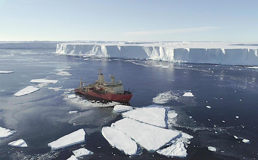
US research ship Nathaniel B. Palmer at the ice front of Thwaites Glacier, taken by drone. Credit Alex Mazur
This mission formed part of the International Thwaites Glacier Collaboration (ITGC), a five-year, $50 million joint U.S. and U.K. mission to learn more about Thwaites Glacier, its past, and what the future may hold.
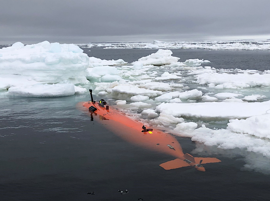
The autonomous underwater vehicle, Ran, was programmed to dive into the cavity of Dotson ice shelf, West Antarctica and scan the ice above it with an advanced sonar. For 27 days, the submarine travelled a total of over 1,000 kilometres (around the distance of a return trip from Edinburgh to London, as the crow flies) back and forth under the glacier, reaching 17 kilometres into the cavity above which the ice shelf floats.
The expedition was carried out in regions of drifting ice in West Antarctica in 2022. On the return visit in 2024, Ran disappeared without a trace under the ice. Photo: Filip Stedt
In a new scientific paper in Science Advances, the researchers report on the findings of this unique survey. Scientists already knew that glaciers melt faster where strong underwater currents erode their base. Using the submersible, scientists were able to measure the currents below the glacier for the first time and prove why the western part of Dotson Ice Shelf melts so fast. They also found evidence of very high melt at vertical fractures that extend through the glacier.
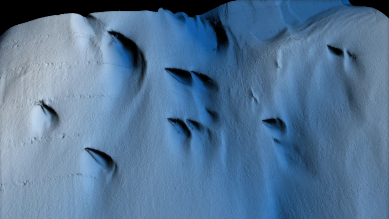
But the researchers also saw new patterns on the glacier base that raise questions. For example, the base is not smooth, but has a peak and valley ice-scape with plateaus and formations resembling sand dunes. The researchers hypothesise that these may have been formed by flowing water under the influence of Earth’s rotation.
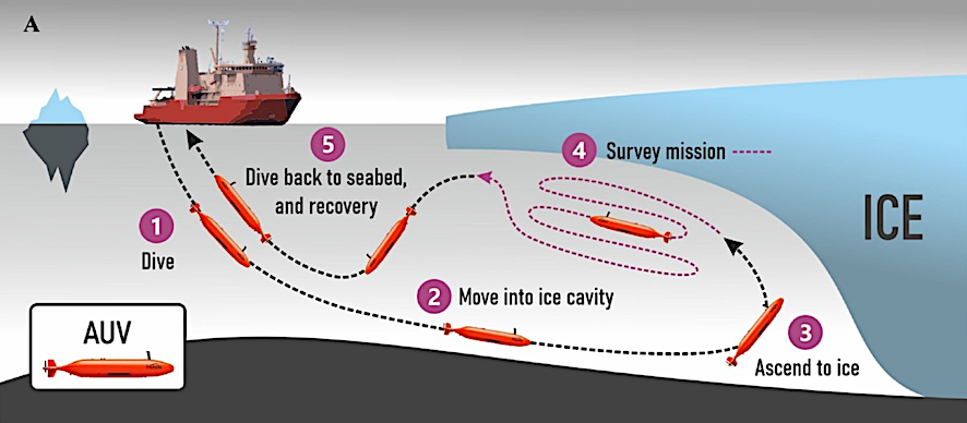
The autonomous underwater vehicle Ran was programmed to perform missions under the ice shelf. An advanced multibeam sonar was used to map the base of the ice at a distance of about 50 metres. Illustration: Anna Wåhlin/Science Advances
Lead author Anna Wåhlin, Professor of Oceanography at the University of Gothenburg says: “We have previously used satellite data and ice cores to observe how ice shelves change over time. By navigating the submersible into the cavity, we were able to get high resolution maps of the ice underside. It’s a bit like seeing the back of the moon for the first time,” says lead author.
Karen Alley, a glaciologist from the University of Manitoba and co-author of this multidisciplinary study, comments on the findings: “The maps that Ran produced represent a huge progress in our understanding of Antarctica’s ice shelves. We’ve had hints of how complex ice-shelf bases are, but Ran uncovered a more extensive and complete picture than ever before.”
Current models can’t explain the patterns discovered, and scientists now realise there is a wealth of processes left to discover in future research missions under the glaciers.
BAS researchers were involved in visualising the data collected by Ran. Rob Larter, a marine geophysicist at BAS, and co-author of the paper says: “The upward-looking sonar data from Ran enabled more extensive, detailed maps of the underside of an ice shelf to be made than have ever been available before. This has provided new insights into the interactions between the ice, fractures within it and water flowing beneath it.”
Dotson Ice Shelf is part of the West Antarctic ice sheet, considered to have a potentially large impact on future sea level rise due to its size and location. Rob adds: “Basal melting of ice shelves resulting from incursion of warm water beneath them is the main driver of ice loss from large West Antarctic glaciers, including Pine Island and Thwaites glaciers. Therefore, better understanding of these interactions is critical to improving predictions of Antarctic contributions to sea-level rise.”
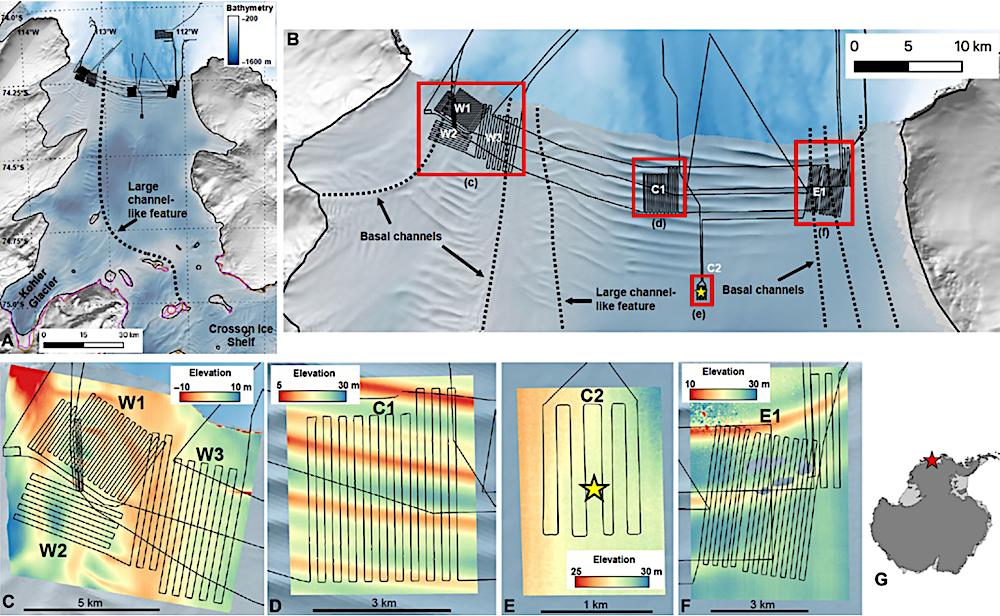
Dotson Ice Shelf. (A and B) Reference Elevation Model of Antarctica mosaic (66) of DIS with the regions and features discussed in the text labeled: basal channel features (dashed lines), ~2000 Landsat-derived grounding line [thick black lines; (67)], and 1992–2020 Interferometric Synthetic Aperture Radar–derived grounding lines [pink lines; (68, 69)]. Thin black lines show the AUV mission paths, and red squares in (B) show the location of the zoomed-in areas in (C) to (F). Blue shades show bathymetry (70) [color bar in (A)]. [(C) to (F)] Zoomed-in areas showing the ice surface elevation at the survey areas, referenced to the WGS84 ellipsoid. The yellow star in (E) shows the location of the hot water drilling site. (G) Study area location.
The field work for this study was conducted in 2022. In January 2024, the group returned with Ran to Dotson Ice Shelf to repeat the surveys, hoping to document changes. They were only able to repeat one dive below Dotson ice shelf before Ran disappeared without a trace. “Although we got valuable data back, we did not get all we had hoped for. These scientific advances were made possible thanks to the unique submersible that Ran was. This research is needed to understand the future of Antarctica’s ice sheet, and we hope to be able to replace Ran and continue this important work,” says Anna Wåhlin.
Swirls and scoops: Ice base melt revealed by multibeam imagery of an Antarctic ice shelf, Science Advances
Astrobiology