History Of Ceres’s Young Cold Traps
Ceres, the largest asteroid in our Solar System, harbors a dark secret: Extremely young ice deposits in permanently shadowed craters near its poles. If that sounds vaguely familiar, it’s because our Moon and planet Mercury also have such polar ice deposits, which have been studied for decades.
“For Ceres, the story started in 2016, when the Dawn spacecraft, which orbited around Ceres at the time, glimpsed into these permanently dark craters and saw bright ice deposits in some of them,” said Norbert Schorghofer, lead author of “History of Ceres’s Cold Traps Based on Refined Shape Models”that appears in The Planetary Science Journal. PSI scientists Robert Gaskell and John Weirich, and NASA Goddard Space Flight Center Scientist Erwan Mazarico, are coauthors on the paper.
“The discovery back in 2016 posed a riddle: Many craters in the polar regions of Ceres remain shadowed all year – which on Ceres lasts 4.6 Earth years – and therefore remain frigidly cold, but only a few of them harbor ice deposits,” Schorghofer said. “Soon, another discovery provided a clue why: The rotation axis of Ceres oscillates back and forth every 24,000 years due to tides from the Sun and Jupiter. When the axis tilt is high and the seasons strong, only a few craters remain shadowed all year, and these are the craters that contain bright ice deposits.”
To determine how large shadows were inside of craters thousands of years ago, scientists construct digital elevation maps and then perform ray-tracing calculations with them to theoretically reconstruct the shadows cast on the crater floors. The results are only as reliable as the digital shape models on which they are based. Keep in mind that the floors of these craters are always in shadow, so it is not easy to measure how deep they are.
The Dawn spacecraft had a very sensitive camera, which could discern features on the shadowed crater floors. Stereo images of sunlit regions are often used to construct digital elevation maps of sunlit regions, but making an elevation map of shadowed terrain is a challenge that had rarely been taken on. As part of the new study, PSI scientist Robert Gaskell developed a new technique to reconstruct heights even in the shadowed portions of a stereo pair of images. These improved elevation maps can then be used for ray-tracing to predict the extent of cold, permanently shadowed regions.
These more accurate maps yielded a surprising result: When Ceres reaches its maximum axis tilt, which last occurred about 14,000 years ago, no crater on Ceres remains perennially shadowed and any ice in them must have quickly sublimated into space. “That leaves only one plausible explanation: The ice deposits must have formed more recently than that. The results suggest all of these ice deposits must have accumulated within the last 6,000 years or less. Considering that Ceres is well over 4 billion years old, that is a remarkably young age,” Schorghofer said.
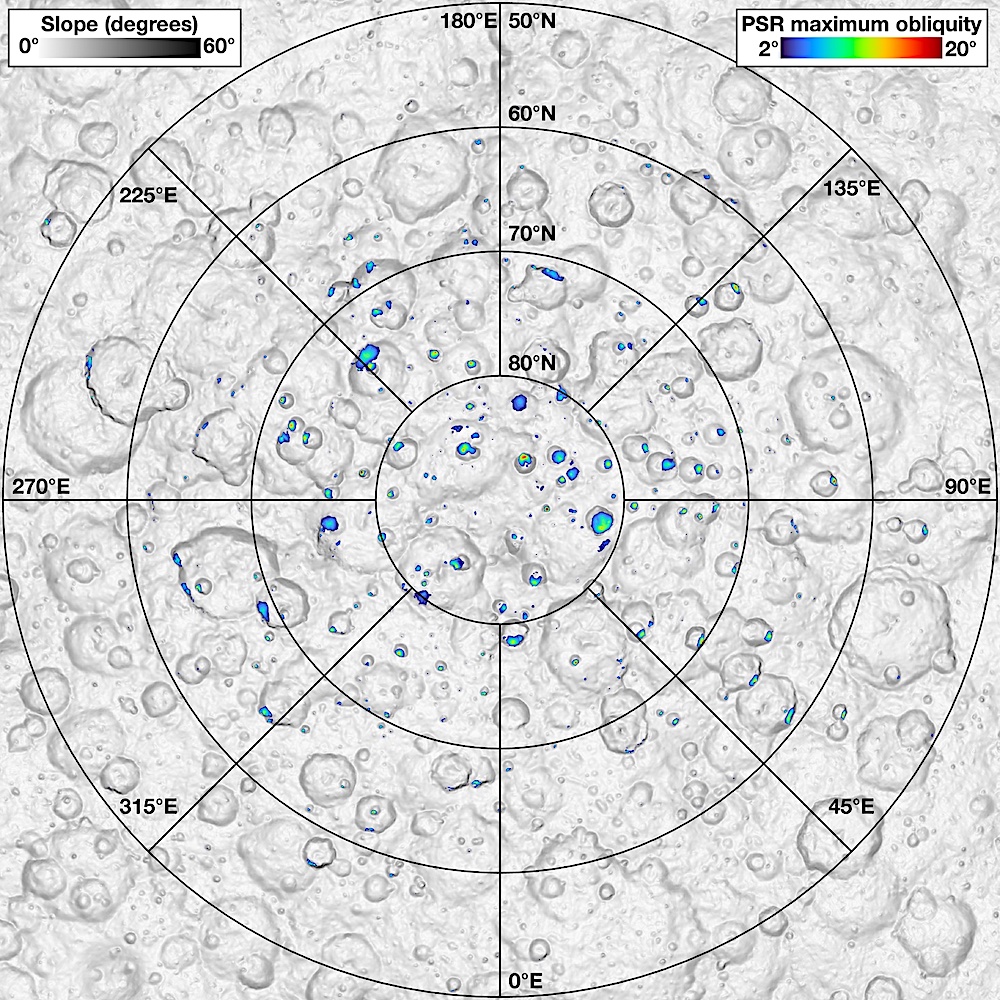
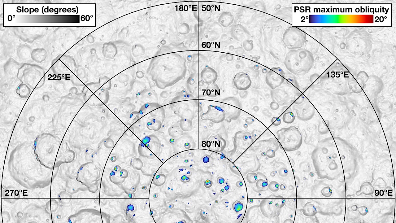
Map of the north polar region of Ceres. The color areas are areas that are continuously shadowed over a Ceres year, and therefore very cold. The axis tilt (obliquity) of Ceres slowly changes over time and is currently 4 degrees, but ranged between 2 and 20 degrees over time. The color indicates the maximum obliquity at which a location is in shadow through an entire orbit. Credit: Erwan Mazarico/GSFC.
“Ceres is an ice-rich object, but almost none of this ice is exposed on the surface. The aforementioned polar craters and a few small patches outside the polar regions are the only ice exposures. However, ice is ubiquitous at shallow depths – as discovered by PSI scientist Tom Prettyman and his team back in 2017 – so even a small dry impactor could vaporize some of that ice.” Schorghofer said. “A fragment of an asteroid may have collided with Ceres about 6,000 years ago, which created a temporary water atmosphere. Once a water atmosphere is generated, ice would condense in the cold polar craters, forming the bright deposits that we still see today. Alternatively, the ice deposits could have formed by avalanches of ice-rich material. This ice would then survive in only the cold shadowed craters. Either way, these events were very recent on an astronomical time scale.”
The study also looked into the possibility that other types of ices, other than water ice, might be trapped in these unusual craters on Ceres. On our Moon, portions of polar craters are so cold that even CO2 ice and a few other chemical species could last in them for billions of years. Ceres is farther from the Sun, so its polar craters could be expected to be even colder than the Moon’s.
Schorghofer calculated temperatures inside Ceres’s polar craters, something that had never been done before. The answer was surprising: although these craters are cold enough to retain water ice, they are too warm to retain other common types of ice. Two circumstances contribute to this. First, the axis tilt of Ceres, currently 4 degrees, is higher than the Moon’s 1.5 degree tilt, so more of the crater rims are sunlit and more light is scattered onto the crater floor. Second, Ceres simply has no perennially shadowed craters very near the north pole, unlike the Moon, where one crater sits almost exactly on the south pole. For these reasons, temperatures are not as low on Ceres than they are on parts of the lunar surface.
The study describes the new method used to reconstruct topography using stereo images of shadowed craters, provides a new map of perennially shadowed regions for the entire north polar region of Ceres, determines the extent of perennially shadowed regions inside polar craters with bright ice deposits, and estimates the temperatures for the interior of these craters. “Whatever the history of these ice deposits, it resulted from events not much older than human civilization,” Schorghofer said.
This work was funded by a grant from NASA’s Discover Data Analysis Program to PSI (80NSSC21K1033).
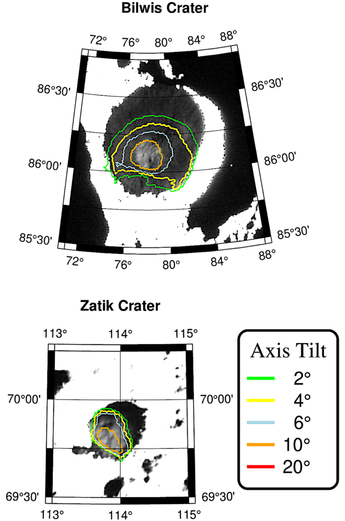
Images of two craters in the north polar region of Ceres captured by the Dawn spacecraft. The shadowed regions contain bright ice deposits, whereas sunlit regions appear saturated (white) in these contrast-stretched images. The superimposed color contours represent the extent of the area that is in shadow over the entire Cerean year for different values of the axis tilt. The current axis tilt is 4 degrees (yellow contour). The bright ice deposits must have accumulated at an axis tilt of 10 degrees or less (orange contour), which last occurred 6,000 years ago. Credit: Norbert Schorghofer/PSI.
THE PLANETARY SCIENCE INSTITUTE:
The Planetary Science Institute is a private, nonprofit 501(c)(3) corporation dedicated to Solar System exploration. It is headquartered in Tucson, Arizona, where it was founded in 1972.
PSI scientists are involved in numerous NASA and international missions, the study of Mars and other planets, the Moon, asteroids, comets, interplanetary dust, impact physics, the origin of the Solar System, extra-solar planet formation, dynamics, the rise of life, and other areas of research. They conduct fieldwork on all continents around the world. They also are actively involved in science education and public outreach through school programs, children’s books, popular science books and art.
PSI scientists are based in 35 states and the District of Columbia.
Astrobiology


