USGS Online Interactive Map Of Europa
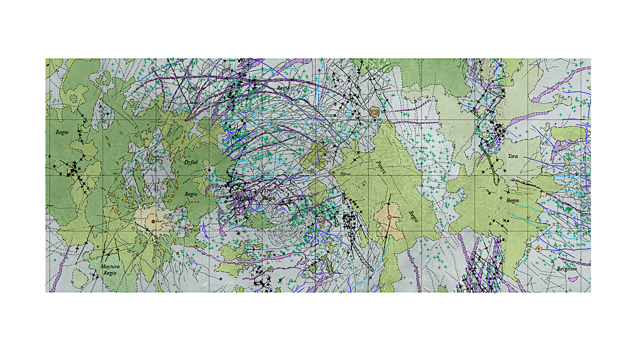
Europa, the second inner Jovian Galilean satellite, is believed to contain a global liquid water ocean covered by an ice shell likely 10s of kilometers thick. The paucity of impact craters suggests that Europa’s surface is geologically young, having undergone extensive resurfacing over the past ~60-100 Ma.
The combination of a young surface and the presence of a global ocean makes this icy world a potentially habitable environment. In order to achieve a better understanding of the relation between the interior and the surface as expressed through its geology, a 1:15,000,000 scale global geologic map of Europa has been produced.
Four areally extensive primary material unit types (regional plains material, band material, chaos material, and crater material) make up the surface and are divided into geologic subunits: (1) Regional plains (pr) material, a high relative brightness material that is smooth at global resolution (>1 km/pixel); (2) Band material (b), linear to curvilinear zones with a distinct, abrupt change in relative brightness from the surrounding region that are also greater than 15 km in width; (3) Various morphological types of chaos material identified as high relative brightness chaos material (chh), mottled chaos material (chm), low relative brightness chaos material (chl), and Moytura chaos material (chM); and (4) Materials associated with impact craters, their local deposits, farther ranging ejecta material and central structure—crater material (c), continuous crater ejecta material (ce), Pwyll radial crater ejecta material (cpre), and Pwyll crater ray material (cpr).
We also identify structures which are too small areally to be mapped as units but are significant enough to be mapped as linear features: ridges, undifferentiated linea, band linea, high relative brightness band linea, cycloids, multi-ring structures, troughs, and depression margins. Microchaos, defined as disrupted terrains whose textures vary with apparent relative brightnesses ranging from high to low, are too small (5-25 km in diameter) to be mapped as a unit at the 1:15,000,000 scale but are ubiquitous and significant enough to be identified on the map as a point feature. There are two additional point features corresponding to structures associated with impact craters—small craters (5-10 km diameter) and central peak structure.
Derived from this map is a global stratigraphic framework for Europa that allows for future quantitative assessment of the distribution of the various geologic terrains. Based on the identifiable cross-cutting relationships between the map units and linear features, three relatively distinct periods in Europa’s surface history are identified: (1) a period dominated by ridge building, (2) a period of band formation, and (3) the most recent period that is dominated by chaos terrain formation. The apparent need for a variety of resurfacing mechanisms to create Europa’s geologically young surface is made especially clear by the lack of craters and the wide variety of tectonic a
This map is for viewing purposes only. Official map products (PDF and GIS files) can be found on the USGS Publications Warehouse page.
Astrobiology, Astrogeology,


