Confirmation Of An Ancient Lake On Mars Builds Excitement For Perseverance Rover’s Samples
If life ever existed on Mars, the Perseverance rover’s verification of lake sediments at the base of the Jezero crater reinforces the hope that traces might be found in the crater.
In new research published in the journal Science Advances, a team led by UCLA and The University of Oslo shows that at some point, the crater filled with water, depositing layers of sediments on the crater floor. The lake subsequently shrank and sediments carried by the river that fed it formed an enormous delta. As the lake dissipated over time, the sediments in the crater were eroded, forming the geologic features visible on the surface today.
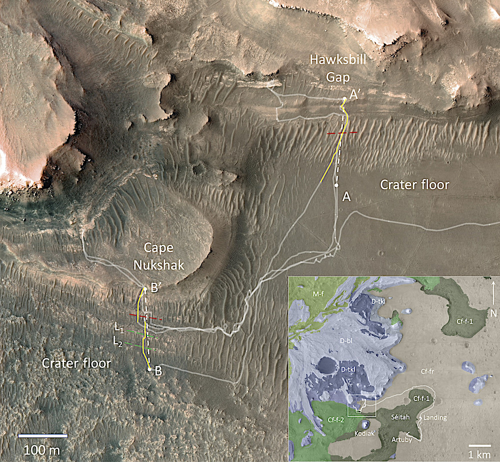
Orbital context maps of the Jezero western delta front region. Orbital High Resolution Imaging Science Experiment (HiRISE) (28) color base map showing the path (pale white lines) of the Perseverance rover across the crater floor and delta front through Sol 706, including contact-crossings at Hawksbill Gap and Cape Nukshak. The white dashed lines show the locations of the projected radar cross sections shown in Figs. 3 and 4. The solid yellow lines show the original pre-projected tracks, the red dashed lines indicate the inferred locations of the crater-floor delta contact from RIMFAX data, and the green dashed lines are the traces of two outcropping crater floor layers (L1 and L2) that can be traced to subsurface radar reflectors (See Fig. 4). The regional insert map shows the rover path since landing as well as the exposed regional bedrock geologic units mapped from pre-landing orbital imagery and spectroscopy (13). Cf-f-1, crater floor fractured 1; Cf-f-2, crater floor fractured 2; Cf-fr, crater floor fractured rough; D-bl, delta blocky; D-tkl, delta thickly layered; M-f, margin fractured.
The periods of deposition and erosion took place over eons of environmental changes, the radar indicates, confirming that inferences about the Jezero crater’s geologic history based on Mars images obtained from space are accurate.
“From orbit we can see a bunch of different deposits, but we can’t tell for sure if what we’re seeing is their original state, or if we’re seeing the conclusion of a long geological story,” said David Paige, a UCLA professor of Earth, planetary and space sciences and first author of the paper. “To tell how these things formed, we need to see below the surface.”
The rover, which is about the size of a car and carries seven scientific instruments, has been exploring the 30-mile-wide crater, studying its geology and atmosphere and collecting samples since 2021. Perseverance’s soil and rock samples will be brought back to Earth by a future expedition and studied for evidence of past life.
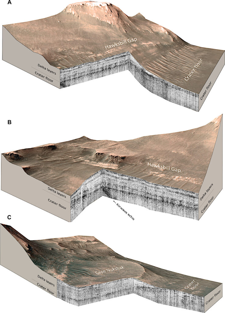
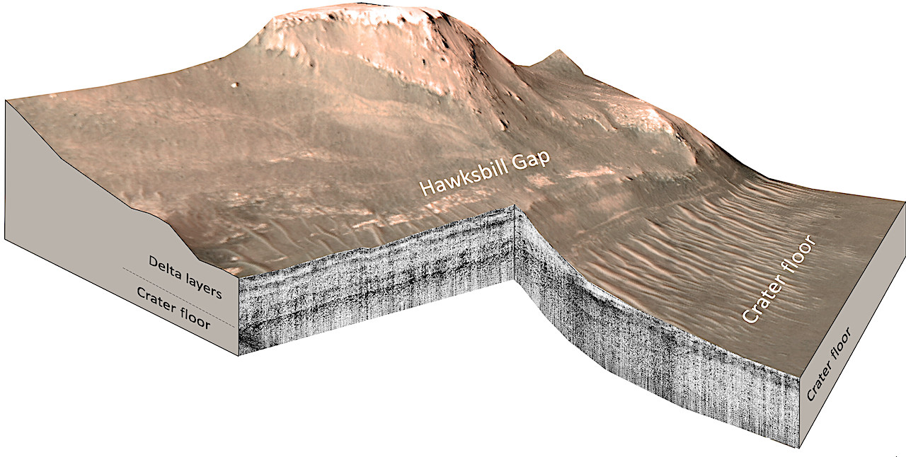
Cross-sectional projected 3D views of the RIMFAX reflection amplitude radargrams. (A) Hawksbill Gap acquired on Sols 535 to 541 and (B) Hawksbill Gap on Sols 449 to 460 and Sols 535 to 537. (C) Cape Nukshak on Sols 420 to 421 and Sols 556 to 632. Strongly reflecting layers are rendered as dark whereas weakly reflecting layers are rendered as light (see Materials and Methods). All views use HiRISE digital elevation model data and are 2× vertically exaggerated.
Between May and December 2022, Perseverance drove from the crater floor onto the delta, a vast expanse of 3 billion-year-old sediments that, from orbit, resembles the river deltas on Earth.
As the rover drove onto the delta, Perseverance’s Radar Imager for Mars’ Subsurface Experiment, or RIMFAX, instrument fired radar waves downward at 10-centimeter intervals and measured pulses reflected from depths of about 20 meters below the surface. With the radar, scientists can see down to the base of the sediments to reveal the top surface of the buried crater floor.
Years of research with ground-penetrating radar and testing of RIMFAX on Earth have taught scientists how to read the structure and composition of subsurface layers from their radar reflections. The resulting subsurface image shows rock layers that can be interpreted like a highway road cut.
“Some geologists say that the ability of radar to see under the surface is kind of like cheating,” said Paige, who is RIMFAX’s deputy principal investigator.
RIMFAX imaging revealed two distinct periods of sediment deposition sandwiched between two periods of erosion. UCLA and the University of Oslo report that the crater floor below the delta is not uniformly flat, suggesting that a period of erosion occurred prior to the deposition of lake sediments. The radar images show that the sediments are regular and horizontal – just like sediments deposited in lakes on Earth. The existence of lake sediments had been suspected in previous studies, but has been confirmed by this research.
A second period of deposition occurred when fluctuations in the lake level allowed the river to deposit a broad delta that once extended far out into the lake, but has now eroded back closer to the river’s mouth.
“The changes we see preserved in the rock record are driven by large-scale changes in the Martian environment,” Paige said. “It’s cool that we can see so much evidence of change in such a small geographic area, which allows us extend our findings to the scale of the entire crater.”
Ground penetrating radar observations of the contact between the western delta and the crater floor of Jezero Crater, Mars, Science Advances (open access)
Astrobiology


