Chaotic Crust Contains Clues To Mars’ Watery Past
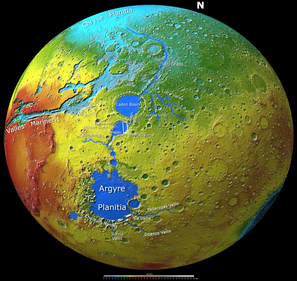
The Holden Basin* is part of a series of channels and sinks called the Uzboi-Ladon-Morava (ULM) outflow system that may have once drained up to 9% of the martian surface. The complex history of the ULM outflow system makes it an interesting target to explore in more detail with Mars orbiters and rovers.
In the maps on the right and directly below, we see the Holden Basin and the full ULM outflow system in context. The solid royal blue colour in the map below shows how water once flowed across this region of Mars; it would have started in channels that drain into the Argyre Planitia, then flowed through Uzboi Vallis into the location now scarred by the Holden Crater. From there it would have collected in the Holden Basin before streaming through Ladon Valles to Ladon Basin and beyond.
The map below also shows Mars’ ‘Grand Canyon’ Valles Marineris, which we delved into in our previous Mars Express image release. Iani Chaos, another chaotic area that we have explored in detail, is visible towards the top of the image.
High-ranking target in the search for life
The entire region could be an interesting target in the search for ancient life on Mars. Our experience on Earth tells us that where there is water, there is life: could the same have been true billions of years ago on Mars?
Ladon Valles and Holden Crater – both of which lie just outside the imaged area, and can be seen in the images showing the broader region – may be particularly interesting as they contain layered and phyllosilicate-bearing deposits. Phyllosilicates are a type of mineral also found on Earth, with one example being clay. They could serve as a reaction centre for organic molecules, which make up all living things on Earth; past experiments suggest that phyllosilicates could have played a role in the origin of life.
The 140-km wide Holder Crater formed when Mars was hit by a space rock; the material that was ejected during the impact filled Holden Basin, which is itself a much older impact crater. As the crater shows no evidence that significant amounts of water flowed through it, it very likely formed after the ULM system had mostly dried out. Due to its interesting geology and potential for clues to past life, Holden Crater was on the shortlist of landing sites for NASA’s Mars Science Laboratory and Perseverance rover.
Exploring Mars
Mars Express has been orbiting the Red Planet since 2003, imaging Mars’ surface, mapping its minerals, identifying the composition and circulation of its tenuous atmosphere, probing beneath its crust, and exploring how various phenomena interact in the martian environment.
The mission’s High Resolution Stereo Camera (HRSC), responsible for these new images, has revealed much about Mars’ diverse surface features, with recent images showing everything from wind-sculpted ridges and grooves through impact craters and channels that once carried liquid water to volcanoes, tectonic faults, river channels and ancient lava pools.
Astrobiology