Evidence And Concerns About A Latent, Embryonic Phase Tectonic Evolution And The Existence Of The Young Subsurface Ocean On Mimas
New models challenge the long-standing conclusion about Mimas, an icy satellite of Saturn, being an inactive snowball, suggesting the existence of a young stealth ocean.
Unfortunately, no observable evidence has been found yet implying tectonic activity and the theoretical subsurface ocean. Here, we present the first structural geological map of the icy satellite, with the signs of various tectonic features, along with a simple crosscutting chronology of lineaments formation. In accordance with the supposedly young age of the stealth ocean, the observed phenomena are described as putative lineaments, ridges, and troughs.
Simple tectonic features are identified as young compared to complex structures. The pattern of the linear features seems to overlap with the allocation of various modeled global nonlinear tidal dissipation patterns. In such a way, it may provide the first observed evidence for the existence of the theoretical subsurface stealth ocean.
However, the overlapping and crosscutting relation between craters and the observed features may raise concerns about the recent formation of such linear features, indicating possibly long-time dormant or already stopped tectonic processes at the early embryonic phase of lineament formation billions of years ago.
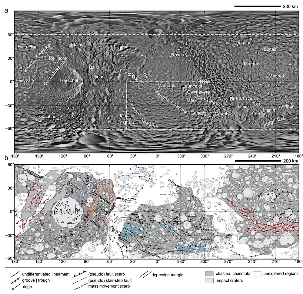
The photomosaic was used during the geological mapping (a) and the delivered global tectonic map (b). a) utilizes the Mimas Global Map – June 2017 version, which can be found on the site of NASA Jet Propulsion Laboratory, California Institute of Technology (https://www.jpl.nasa.gov/images/pia17214-mimasglobal-map-june-2017), as its base map. The applied nomenclature adheres to the recommendation of the Gazetteer of Planetary Nomenclature (https://planetarynames.wr.usgs.gov/Page/MIMAS/target). Because of the distortion caused by the projection system around the polar regions, the regions beyond latitude +/-60° were excluded from the analysis in Figure 1b, as shown by the dashed white lines. The area inside the dotted rectangle is analyzed in Figure 3. The tectonic features marked by various colors indicate various tectonic processes, such as orange – Herschel impact event-related scarps, red – Ithaca Chasma analog features, and different tones of blue – quasi-parallel linear features, selected for further analysis (please find more information in the text at Section 3, and in Figures 2 and 3). — astro-ph.EP
Balazs Bradak, Motoharu Okumi
Subjects: Earth and Planetary Astrophysics (astro-ph.EP)
Cite as: arXiv:2404.14084 [astro-ph.EP] (or arXiv:2404.14084v1 [astro-ph.EP] for this version)
Submission history
From: Balazs Bradak
[v1] Mon, 22 Apr 2024 11:06:06 UTC (1,023 KB)
https://arxiv.org/abs/2404.14084
Astrobiology,